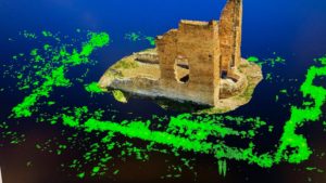
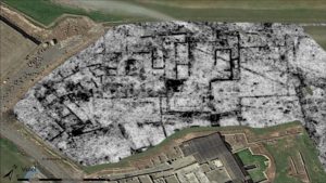
Remote sensing in archaeology involves using aerial imagery geophysics, LiDAR and drones to survey and map large areas of land for potential archaeological sites. This technology can detect buried structures and features that may not be visible on the surface, without the need for excavation. These technologies have revolutionized the field of archaeology, enabling researchers to gather information about the past without destroying the evidence or altering the site in any way. These techniques allow archaeologists to obtain information about the location, size, and layout of buried structures, as well as information about the composition and distribution of artifacts and other archaeological features.
This 3 days, intensive course, is designed to provide an introduction to the various techniques and methods used in the study of archaeological sites and landscapes. We will explore the application and development of non-invasive technologies, their use and limitations in the field of landscape archaeology. The course is designed to be interactive, with a strong emphasis on practical exercises on site and case studies. We will be using a combination of lecture, discussion, and hands-on exercises to gain a deeper understanding of the techniques and methods used in non-invasive archaeology. The case study will be the Sodo archaeological park in Cortona, one of the most important sites in central Etruria.
For info and registration: info@geostudiastier.com